Land surveying helps people figure out where property lines are. If you are building a house, starting a business, or dividing land, you need to know exactly where your land begins and ends. Land surveying in West Grove helps ensure there are no mistakes so you don’t run into problems with neighbors, builders, or the law.
Surveyors use special tools to measure land. They find property boundaries, locate important land features, and make maps that builders and property owners use. Without a survey, you might build in the wrong place, which could cause expensive problems later.
Why Land Surveys Matter
Surveys do more than mark property lines. They help landowners better understand their land. A survey provides a clear view of property boundaries, existing structures, and natural features like hills and streams. Knowing these details is essential when deciding on development, construction, or resolving land disputes.
You need a survey if you buy or sell land. It confirms the exact property lines, preventing future conflicts. When dividing a large piece of land into smaller lots, a survey ensures each section meets local zoning laws. If there is a disagreement over where one property ends and another begins, a survey provides an official record to settle the dispute. Planning a construction project also requires a survey to make sure buildings, driveways, and utilities are placed correctly. In addition, many local governments need a survey before they issue permits for land development in West Grove to confirm zoning compliance.
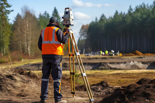
How a Land Survey Works

A land survey involves several steps to ensure accuracy. First, surveyors research property records, including past surveys, deeds, and maps. This helps them understand the historical boundaries of the land.
Next, the surveyor visits the site to take precise measurements. They use GPS technology, laser scanners, and other tools to collect data. These measurements help confirm property boundaries and identify key land features.
After gathering data, surveyors create maps and reports. These documents show property lines, elevation changes, and structures on the land. Finally, the completed survey is given to the property owner, who can use it for legal purposes, construction planning, or property sales.
Types of Land Surveys
Surveying services are different depending on what you need. Here are some common types of land surveys used in land development in West Grove:
Boundary Surveys
These surveys show precisely where a property begins and ends. They provide legal clarity, ensuring that property owners do not encroach on neighboring land. This type of survey is essential when planning to build structures such as fences, sheds, or homes, as incorrect placement can lead to disputes, fines, or even forced removal of the structure. In addition to marking boundaries, these surveys may reveal any existing encroachments, easements, or restrictions that could affect how the land is used.
Topographic Surveys
A topographic survey records the physical features of a property, including hills, valleys, trees, water bodies, and man-made structures. Engineers use this data to design projects that blend with the land’s natural layout, preventing issues such as poor drainage or unstable foundations. This type of survey is also essential for planning infrastructure like roads and utilities, as it helps identify elevation changes and potential problem areas. Builders rely on this information to determine the best approach for grading, ensuring proper water runoff and soil stability, which are critical for safe construction and long-term land use.
Construction Surveys
A construction survey shows where buildings, roads, and utility lines should go. It helps make sure everything is built in the right place and follows approved plans and local rules. Contractors and engineers use these surveys to correctly set up foundations, walls, and roads. Without a proper survey, buildings might be placed incorrectly, leading to expensive mistakes or safety risks. These surveys also check elevation levels to avoid drainage problems that could weaken a structure. By planning everything carefully, construction surveys make building smoother and reduce unexpected issues.
ALTA/NSPS Land Title Surveys
Lenders and title companies need this detailed survey before closing commercial real estate deals. It shows property lines, zoning rules, and any easements affecting land use.
Subdivision Surveys
These surveys divide large pieces of land into smaller sections for sale or development. They ensure that each lot meets local regulations for size, road access, and infrastructure.
The Role of Surveys in Land Developement
Surveys are a key part of land development in West Grove. Every new construction project starts with a land survey. Builders and engineers use these reports to plan roads, drainage, and buildings. Without a survey, projects could run into legal trouble or unexpected issues, which could be expensive to fix.
Many local governments require a certified land survey before issuing building permits. This ensures that everything follows the rules and that new developments do not interfere with existing properties.
How to Pick a Land Surveyor in West Grove
Choosing the right land surveyor is important for getting accurate results. An experienced surveyor will know local land rules, use modern tools, and provide clear documentation. Before hiring a surveyor, consider the following factors.
A surveyor’s experience matters. Look for someone with a strong track record of completing different types of land surveys. Licensing is also important. Make sure the surveyor is certified to work in Pennsylvania. The technology used can also make a difference. Surveyors who use GPS, drones, and laser scanning tools can provide more precise measurements. Lastly, working with a surveyor familiar with land development in West Grove ensures they understand the area’s zoning laws and common land challenges.
Get Reliable Land Surveying Services
If you need land surveying in West Grove, work with a team that provides precise, accurate results. Padula Engineering helps you avoid mistakes and ensures your project stays on track. We also conduct land surveying in West Goshen, land surveying in Pocopson, and professional land surveying in Chadds Ford. For more details about land surveys in West Grove, contact us today.