Before starting any development project, especially in West Chester, one critical step lays the groundwork for success: land surveying. It identifies property boundaries, reveals physical features, and uncovers potential challenges that could impact construction.
Without a proper survey, projects risk delays, legal issues, and unexpected costs. Knowing why land surveying is essential helps you make informed decisions and move forward with confidence.
If you plan to develop land in West Chester, you need a survey to ensure your project follows local zoning rules. Land surveying in West Chester prevents errors that could stop construction or cause problems later.
How Land Surveys Help with Land Development Planning

Every development project needs a plan. And a land survey is the first step in land development planning. It provides the essential details about a property and information required to design roads, buildings, and drainage systems. A survey helps confirm the legal boundaries and helps with land development planning. Without a survey, builders might run into unexpected issues. With one, you can plan where to place buildings, driveways, and utilities.
A survey helps developers avoid zoning violations and ensures that utilities like water, sewer, and electricity are properly installed. Many cities and counties require a land survey before approving development permits.
Surveying also helps developers use land efficiently. It identifies the best locations for buildings and open spaces, preventing wasted space and costly adjustments later.
Common Problems a Land Survey Can Prevent

Skipping a land survey can lead to significant issues. Here are some common problems that accurate surveying helps avoid:
Property Line Disputes
A survey marks where one property ends and another begins. Without this information, neighbors may argue over fences, driveways, or other structures built too close to property lines. A boundary survey provides a legal record that prevents these disputes and ensures everyone knows their land limits. It also protects property owners from costly legal challenges in the future.
Building Mistakes
Without a survey, buildings, fences, and driveways might be placed in the wrong location. This can lead to costly adjustments, fines, or even the removal of structures. A survey ensures construction happens in the right place, preventing future issues and keeping projects on track. It also gives property owners confidence that their investment is protected.
Permit Delays
As earlier stated, many cities and counties require a land survey before issuing building permits. If you do not have a complete survey, you may delay a project until proper documentation is provided. Having a survey ready speeds up the approval process and avoids unnecessary setbacks.
Unexpected Land Conditions
Land may have hidden issues like slopes, flood zones, or underground utilities. A survey reveals these details before construction begins, helping builders make necessary adjustments to prevent flooding, foundation issues, or damage to underground infrastructure.
Legal Problems
A certified survey is an official legal document that protects property owners in disputes. If someone challenges property lines or claims ownership of part of the land, a survey provides the evidence needed to resolve the issue in court. It also ensures compliance with zoning laws, reducing the risk of legal complications.
Steps to Conduct a Land Survey
Understanding how a land survey is done can help property owners and developers know what to expect. Here are the key steps involved in a land survey:
- Research and Records Review – The surveyor starts by researching historical records, previous surveys, and legal documents related to the property. This includes checking deeds, plats, and zoning regulations.
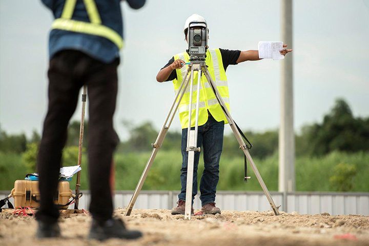
- Site Visit and Data Collection – Surveyors visit the property with specialized tools like GPS, total stations, and laser scanners. They take precise measurements and identify key land features such as boundaries, elevations, and existing structures.
- Boundary Marking – Property lines are identified and marked with stakes, flags, or permanent markers. This step ensures that property owners know the exact extent of their land.
- Mapping and Analysis – After collecting data, surveyors create a detailed map that shows the boundaries, topography, and any easements or encroachments. These maps are essential for planning construction and resolving legal issues.
- Final Report and Certification – The surveyor prepares a final report with all findings, including legal descriptions, measurements, and maps. This document can be used for property transactions, development planning, or legal purposes.
Do You Need a Survey Before Buying Land?
Yes. A survey confirms the exact property lines and prevents future disputes. Without a survey, you might unknowingly purchase land with boundary issues, easements, or encroachments from neighboring properties. It provides an official record that ensures you get precisely what you are paying for. A survey also identifies zoning restrictions, which could affect your intended land use. Mortgage lenders and title companies often require a land survey before finalizing a sale to ensure there are no legal complications.
Choosing a Land Surveyor in West Chester
Not all surveyors provide the same level of accuracy. When hiring a surveyor, consider their experience, certifications, and knowledge of local land laws. An experienced surveyor understands land surveying in West Chester and knows the zoning regulations in the area.
It’s also important to choose a surveyor who uses modern equipment. GPS, drones, and laser scanning tools improve accuracy and efficiency. Another key factor is clear documentation. A good surveyor provides detailed reports that are easy to understand.
So, if you want professional land surveying services in West Chester, visit Padula Engineering and work with experienced professionals who provide clear and accurate results.
For reliable land surveying services, contact Padula Engineering today.